Pest Detection
Pest detection As in the case with disease detection, pests often leave hallmark traces of activity. When these indications are spotted early via multispectral data,
Drones is revolutionizing multipe fields like terrain mapping, precision agriculture, mining industries, life stock management and other industries. I2R labs has been dedicated to development and improvement of Drone technologies and application to meet the demands. Our product folio is a testament to fact that we didn’t want to be left behind in the emrgering technolgies. Use of Drone is continuously increasing and so is AI, combining these two technologies will see the dawn of a new revolution and with our expertise in AI and Drone we will be in the forefront to meet the demands. We strive to provide complete solution from Identifying Opportunity, Designing solution, Deployment and Maintenance. All Drones and its AI application in our portfolio been fully developed in house.
Our Business Model:
We have developed two types of drone for various applications.
We at i2r labs have developed in house multispectral camera which can be mounted to our drones. Using this camera, you can see different spectrums that are not visible to the naked eye.The use of new technologies in agriculture is playing a key role in improving the efficiency of large farming operations and multispectral technology is no exception. The data captured by drone-based multispectral sensors can make operations more efficient by providing information that allows for better use of resources andmore localized applications.
Agricultural drones provide growers, service providers, and ag researchers a fast and efficient way to scout their crops, identify stress, create treatment plans, track plant growth, and much more.
Using high-resolution RGB cameras and professional multispectral sensors, drones can detect and quantify crop health problems early on. These valuable insights can reduce input costs and boost yield.
Drones usage in mining operations quickly realize the significant added value to their industry. Drones in mining improve the overall efficiency of large mine site and quarry management by providing accurate and comprehensive data detailing site conditions in a very short time. They also support better coordination among teams onsite and internationally, offering dynamic oversight of all operations.Above all, this data can be safely produced by on-site workers who have minimal surveying experience at a fraction of the cost of traditional survey methods. By providing thousands of data points for one stockpile, drone surveys are far more accurate than surveying with total stations. All surface unevenness and undulation is identified. The surveys make it possible to reduce the deviation in stockpile volume calculations, to generate improved base files for stockpiling, and to produce more accurate financial statements and regulatory checks.
A drone is mainly used in the construction industry for surveying and inspection purposes. Drones are equipped with downward-facing sensors, such as RGB, multispectral, thermal or LIDAR, and they can capture a great deal of aerial data in a short time.
Companies building and managing large infrastructure such as roads, railways, bridges, dams, water reservoirs, airports, industrial complexes, oil and gas operations, and power complexes have considerable potential to use drone data to optimize their operations
Surveying with a drone offers enormous potential to GIS professionals. With a drone, it is possible to carry out topographic surveys of the same quality as the highly accurate measurements collected by traditional methods, but in a fraction of the time. This substantially reduces the cost of a site survey and the workload of specialists in the field.
DRONE TYPES
SPRAYER
VTOL
MULTISPECTRAL CAMERA
AGRICULTURE
WEED
VEG HELTH
VEG HELTH
DIESEASE
MINING AGGREGATES
STOCKPILE MANGEMENT
MINING SENSOR
CONSTRUCTIONION AND INFRA
ROAD REPAIR
DEPTH
SOLAR PANEL
SURVEYING AND GIS
LIFE STOCK
SURVALENCE
DRONE BASED VIDEO STREAM
Drones is revolutionizing multipe fields like terrain mapping, precision agriculture, mining industries, life stock management and other industries. I2R labs has been dedicated to development and improvement of Drone technologies and application to meet the demands. Our product folio is a testament to fact that we didn’t want to be left behind in the emrgering technolgies. Use of Drone is continuously increasing and so is AI, combining these two technologies will see the dawn of a new revolution and with our expertise in AI and Drone we will be in the forefront to meet the demands. We strive to provide complete solution from Identifying Opportunity, Designing solution, Deployment and Maintenance. All Drones and its AI application in our portfolio been fully developed in house.
Our Business Model:
Pest detection As in the case with disease detection, pests often leave hallmark traces of activity. When these indications are spotted early via multispectral data,
Monitor large acreages Managing large farms requires lots of time and work – even in the most efficient farming operations growers may not have access
Terrain modelling One of the advantages of a calibrated multispectral sensor is the generation of aligned outputs, which can be used to create digital surface
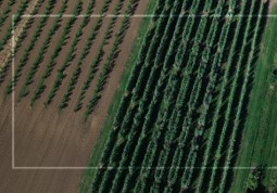
Advanced crop scouting It is not always easy to stay up to date and aware of the problems that can be happening at the plant
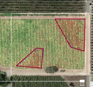
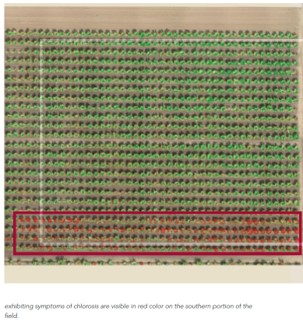
Detect and monitor nutrient deficiencies Nutrient deficiencies often produce symptoms like chlorosis, low plant vigor, slowed growth, and low biomass. Most of these symptoms are invisible
Temporal analysis It is important to monitor a crop throughout the season, but accurate data comparison is only possible with a radiometrically calibrated sensor. Calibration
Input monitoring Fertilizers represent one of the highest input costs for farming operations and one of the most difficult aspects to manage. If applied in
COST REDUCTION Walking the fields will always be a part of farming, but getting out and walking large extensions costs an arm and a leg.
Identify and map drainage tiles A multispectral sensor with five bands allows for the creation of multiple indices. Similar to NDVI, the NDRE index uses
Fruit and crop Detection estimation One of the new applications in the field of artificial intelligence is estimating the amount of fruit in the garden.
I2R Labs,
LISTEN: We listen to customer and provide the best.
SOLVE: With superb R&D base, we are able to design.
HELP: With our product, it help to reduce overall operational cost, enhance efficiencies and provide service auditing.