Drone-Based Video Streaming
Drone-based video streaming Our UAV drones can be used too send live videos several kilometers away. The range tested by us is about 12 km.
Drones is revolutionizing multipe fields like terrain mapping, precision agriculture, mining industries, life stock management and other industries. I2R labs has been dedicated to development and improvement of Drone technologies and application to meet the demands. Our product folio is a testament to fact that we didn’t want to be left behind in the emrgering technolgies. Use of Drone is continuously increasing and so is AI, combining these two technologies will see the dawn of a new revolution and with our expertise in AI and Drone we will be in the forefront to meet the demands. We strive to provide complete solution from Identifying Opportunity, Designing solution, Deployment and Maintenance. All Drones and its AI application in our portfolio been fully developed in house.
Our Business Model:
We have developed two types of drone for various applications.
We at i2r labs have developed in house multispectral camera which can be mounted to our drones. Using this camera, you can see different spectrums that are not visible to the naked eye.The use of new technologies in agriculture is playing a key role in improving the efficiency of large farming operations and multispectral technology is no exception. The data captured by drone-based multispectral sensors can make operations more efficient by providing information that allows for better use of resources andmore localized applications.
Agricultural drones provide growers, service providers, and ag researchers a fast and efficient way to scout their crops, identify stress, create treatment plans, track plant growth, and much more.
Using high-resolution RGB cameras and professional multispectral sensors, drones can detect and quantify crop health problems early on. These valuable insights can reduce input costs and boost yield.
Drones usage in mining operations quickly realize the significant added value to their industry. Drones in mining improve the overall efficiency of large mine site and quarry management by providing accurate and comprehensive data detailing site conditions in a very short time. They also support better coordination among teams onsite and internationally, offering dynamic oversight of all operations.Above all, this data can be safely produced by on-site workers who have minimal surveying experience at a fraction of the cost of traditional survey methods. By providing thousands of data points for one stockpile, drone surveys are far more accurate than surveying with total stations. All surface unevenness and undulation is identified. The surveys make it possible to reduce the deviation in stockpile volume calculations, to generate improved base files for stockpiling, and to produce more accurate financial statements and regulatory checks.
A drone is mainly used in the construction industry for surveying and inspection purposes. Drones are equipped with downward-facing sensors, such as RGB, multispectral, thermal or LIDAR, and they can capture a great deal of aerial data in a short time.
Companies building and managing large infrastructure such as roads, railways, bridges, dams, water reservoirs, airports, industrial complexes, oil and gas operations, and power complexes have considerable potential to use drone data to optimize their operations
Surveying with a drone offers enormous potential to GIS professionals. With a drone, it is possible to carry out topographic surveys of the same quality as the highly accurate measurements collected by traditional methods, but in a fraction of the time. This substantially reduces the cost of a site survey and the workload of specialists in the field.
DRONE TYPES
SPRAYER
VTOL
MULTISPECTRAL CAMERA
AGRICULTURE
WEED
VEG HELTH
VEG HELTH
DIESEASE
MINING AGGREGATES
STOCKPILE MANGEMENT
MINING SENSOR
CONSTRUCTIONION AND INFRA
ROAD REPAIR
DEPTH
SOLAR PANEL
SURVEYING AND GIS
LIFE STOCK
SURVALENCE
DRONE BASED VIDEO STREAM
Drones is revolutionizing multipe fields like terrain mapping, precision agriculture, mining industries, life stock management and other industries. I2R labs has been dedicated to development and improvement of Drone technologies and application to meet the demands. Our product folio is a testament to fact that we didn’t want to be left behind in the emrgering technolgies. Use of Drone is continuously increasing and so is AI, combining these two technologies will see the dawn of a new revolution and with our expertise in AI and Drone we will be in the forefront to meet the demands. We strive to provide complete solution from Identifying Opportunity, Designing solution, Deployment and Maintenance. All Drones and its AI application in our portfolio been fully developed in house.
Our Business Model:
Drone-based video streaming Our UAV drones can be used too send live videos several kilometers away. The range tested by us is about 12 km.
Surveillance Using artificial intelligence and UAVs, objects on the ground can be detected andintercepted. Uses such astraffic control or securitychecks. Traffic monitoring via drones can
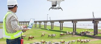
Livestock Management A system like counting cattle could be really time consuming. We can do automation of various procedures involved in livestock management through an
Surveying & GIS Surveying with a drone offers enormous potential to GIS professionals. With a drone, it is possible to carry out topographic surveys of
Solar panel, wind turbine and Pipeline Inspection More than most industries, efficiency plays a very critical role in sustaining solar energy generation and operations which
Depth Estimation These drones are able to provide the areas they have mapped with depth coordinates. These depth coordinates are very important for urban planning
Road Repair, Maintenance and Survey One of the applications of artificial intelligence in UAVs is continuous monitoring of suburban roads. In this method, surveillance drones
Construction and infrastructure A drone is mainly used in the construction industry for surveying and inspection purposes. Drones are equipped with downward-facing sensors, such as
Mining Sensor Lorem ipsum dolor sit amet, consectetur adipiscing elit, sed do eiusmod tempor incididunt ut labore et dolore magna aliqua. Egestas purus viverra accumsan
Magnetic Survey A magnetic survey is one of the exploration tools used for measuring localized changes in the Earth’s magnetic field, caused by sedimentary rocks
I2R Labs,
LISTEN: We listen to customer and provide the best.
SOLVE: With superb R&D base, we are able to design.
HELP: With our product, it help to reduce overall operational cost, enhance efficiencies and provide service auditing.